Natural and artificial control points
Natural and Artificial Control Points:
- are used to georeference optical remote sensed imagery (see geometric corrections).
- are features (e.g. street corners, road markings, individual trees) that are identifiable in the field and in the image and did not change in position, between the time of image and field data acquisition. Georeferencing used to improve image position and reduce mis-registration between field and image data.
- need to cover spatial extent of the study area (e.g. image and its reef)
- can be measured with GPS or Differential GPS depending on availability
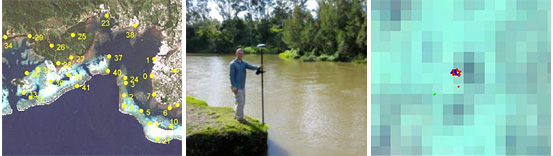
Natural control points distributed throughout the extent of the satellite image.
Differential GPS located close to control points while recording the coordinates.
Position of GPS plotted on top of the control point visible in the high spatial resolution satellite image (Quickbird 2, with 2.4 m x 2.4 m pixel size)