Time and cost
Time needed to conduct a mapping and monitoring project from start to finish and the associated cost varies per monitoring option, biophysical variable and environment type.
To provide for each individual case in the toolkit the associated time and cost falls out of the scope of the toolkit. The following pages will provide some consideration in relation to time and cost:
Total time and cost of a project is determined by: possible start up cost (considered once off), and the actual cost needed to conduct the work on a specific project. In general it can be noted that the cost will be a trade off between ith the quality of field and image data used, and the complexity of image processing applied to it. see example below.
Basic approach
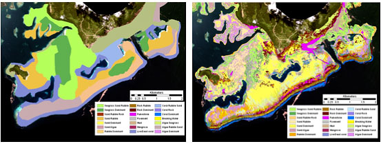
Manual delineation of uncorrected Landsat thematic Mapper 5 image integrated with local knowledge.
Complex approach
Supervised classification of fully corrected high spatial resolution QuickBird imagery integrated with georeferenced photo transect data.
| Basic approaches have low cost and accuracy | Complex approaches have higher cost and accuracy |
References:
Roelfsema, C.M., and S.R. Phinn (2010). Calibration and Validation of Coral Reef Benthic Community Maps: Integration of Field Data with High Spatial Resolution Multi Spectral Satellite Imagery. Journal of Applied Remote Sensing.
Roelfsema, C.M. and S.R. Phinn (2008). Evaluating Eight Field and Remote Sensing Approaches for Mapping the Benthos of Three Different Coral Reef Environments in Fiji. In: Proceedings of SPIE Asia Pacific Remote Sensing Conference – Remote Sensing of Inlands, Coastal and Oceanic Water, Noumea, New Caledonia, 17-21 November 2008, Volume 7150.