What is remote sensing?
Remote sensing is any form of measurement where the measurement device is not in direct contact with the target. For example, the temperature of a water body can be measured directly by placing a thermometer in the water, or indirectly using a satellite sensor that measures emitted thermal energy from the water, which can be converted to temperature.
In terrestrial environments remote sensing techniques are usually applied to map: the type of material or feature(s) present on the ground (e.g. sand, grass, trees, forest) and their biophysical properties, including physical structure (height of trees, biomass) and bio-chemical properties (chlorophyll concentration, water content, amount of light absorbed for photosynthesis). A range of remote sensing instruments can be used in terrestrial environments, including passive sensors which rely on reflected sunlight or emitted thermal energy and active systems, such as radar or airborne laser, which generate their own source of illumination.
Understanding remote sensing images
Images recorded by passive systems (Figure 1) contain a record of how sunlight in specific wavelength regions is absorbed, transmitted and scattered by the atmosphere, vegetation, ground-cover features and water bodies. Understanding and processing remotely sensed images requires an understanding of all the interactions.
This toolkit focuses mainly on passive systems and describes their use in terrestrial mapping, monitoring and modelling applications in a range of environments e.g. savannas, rain forest, riparian forest, desert, and urban areas.
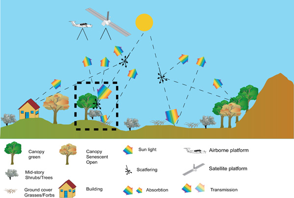
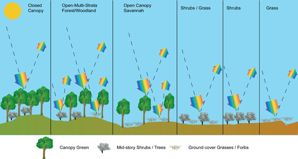
At canopy, mid-story and ground levels (Figure 2) a range of different light interactions occur, depending on the type of environment being imaged. We have shown six main vegetation community structures for these interactions:
- Forest - closed canopy with multiple strata of foliage
- Forest/woodland - open canopy with multiple strata of foliage
- Forest woodland, savanna - open canopy
- Shrubs mixed with grass
- Shrubs
- Grass
Each of these vegetation community structures has physical characteristics which influence how light is reflected, absorbed and scattered. In some cases, the vegetation structure also varies seasonally, or in response to moisture and heat stress, by changing colours in leaves or losing leaves.
Attributes of remote sensing data
Spatial dimensions
- This refers to the width, length and area covered by a satellite or airborne image (e.g. 10 km x 10 km) and the pixel size, e.g. 2.4 m and 30 m in the Quickbird and Landsat Thematic Mapper images below.
- These dimensions, along with size of features in an environment, control the level of detail and size of features able to be mapped.
- See example.
Type of sensor
- Images can either be from passive or optical sensors.
- Passive systems measure reflected sunlight and cannot operate through smoke or cloud or at night.
- Active systems illuminate the target with their own source of energy and measure the response, this includes acoustic, imaging radar and airborne laser systems.
Type of spectral bands (light)
- An additional control on the type of information measured is the number and placement of spectral bands, which are the regions in which reflected or emitted light are measured. Multispectral systems measure fewer than 10 bands and hyper spectral systems cover > 10 bands.
Frequency and time of image acquisition
- Images are acquired by sensors on satellites which are typically in polar orbit with a regular revisit time, that is they collect an image over a set location at the same time at a regular repeat cycle. For some sensors, often with pixels > 250m, this is a daily repeat. For other sensors it may vary from 4-16 days and may be less if the sensor has pointable optics.
Transforming remote sensing data to information
- Once an image for an environment has been acquired it is then subject to a sequence of image processing operations to allow it to be integrated with other spatial data and to represent a thematic (Figure 2) or continuous map of the variable of interest. A number of approaches are available to conduct this type of processing and to deliver useful maps.
Terrestrial environment features that restrict the use of remote sensing for mapping biophysical features
Mapping of terrestrial features from image data sets is complicated by the following factors:
- Terrain height: difference in terrain height within an image can cause distortion of what is on the ground.
- Object shade; can be caused by high trees, buildings or aspect and slope, as a result it reduces the quality of the image classification
- Cloud cover: unable to correct for
- Cloud shade: reduce the quality but can correct for
- Smoke: difficult to correct for depending on the thickness