Spatial dimensions
Spatial resolution: Fine, medium and coarse pixels
The spatial scale of remotely sensed data have been categorised into:
- Fine < 5m
- Medium 5 m - 100 m
- Coarse >100 m
High resolution: 2.4m pixel
Medium resolution: 25m pixel
Relationship between spatial resolution and spatial extent
The spatial dimensions of an image or imaging sensor ecompass both (1) the pixel size; and (2) the extent of the area covered by the image. These are interrelated as shown in the following diagram:
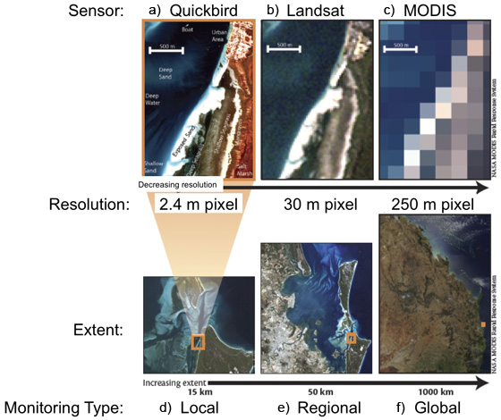
These true-color images show the variation in spatial sampling unit (pixel) and aerial coverage (extent)
between three commonly-used satellite imaging sensors: Quickbird, Landsat Thematic Mapper, and Terra-MODIS.
Figure a-c show the effects of differences between pixel sizes, and resultant spatial resolutions for the same area of
water-seagrass-mangrove-urban area in Moreton Bay, Australia. Figures d-f show the section of one image captured
by each of the three image sensors. The maximum extent of ground width able to be imaged by each sensor is 16 km
(Quickbird), 185 km (Landsat TM), and 2000 km (MODIS)
Reference
Reference: Phinn, S.R, Roelfsema, C.M. and Stumpf, R. (2009). Remote sensing: the promise and the reality. In: Dennison, W., (Ed.) Coastal Assessment Handbook, Chapter 15, University of Maryland.