Mapping biophysical change
Change detection uses two sequential images of the same area to either:
- identify regions of significant change in surface reflectance (pixel value) or a biophysical property; or
- map the transition from one thematic class to another (e.g. seagrass to sand)
For both cases, it is essential that the two images meet ALL pre-processing requirements.
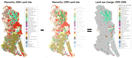
Mapping biophysical change: To generate a map of change in land use, the 1999 image was subtracted from the 2006 image.
If using two images, or image maps of a biophysical variable (e.g. SST), the successive images can be subtracted to divided to produce a difference image.
If using two thematic maps (e.g. groundcover types), the post-classification comparison technique should be used to produce an output map showing the initial and final state of each pixel.
Note that the accuracy of the change product is a product of the accuracy of the two input images.