Object based analysis
Processing sequence for object-based image analysis (OBIA): OBIA is a technique can analyses image data at the object level through clustering of pixels into homogenous objects. The objects are then classified into land-cover classes based on their spectral, shape, locational and contextual characteristics through the development of rule sets.
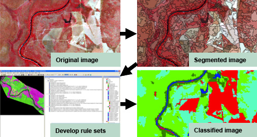
Object-based image analysis of satellite image of parts of the Daly River in the Northern for mapping general land cover classes.
References:
Blaschke, T. 2010. "Object based image analysis for remote sensing." Journal of Photogrammetry and Remote Sensing.
Phinn, S. R., C. M. Roelfsema and P. J. Mumby (in press). "Multi-scale image segmentation for mapping coral reef geomorphic and benthic community zone." International Journal of Remote Sensing.