Transect surveys
Transects for measuring canopy cover in riparian zones: 1. Measuring canopy cover with digital camera and fisheye lens at 5 m intervals along GPS marked transect lines. 2. Sighting tube used for point based assessed of canopy elements, i.e. leaves, branches, dead leaves, and sky. These measurements with known location can be related to high spatial resolution image data to calibrate and validate predictive models for mapping canopy cover.
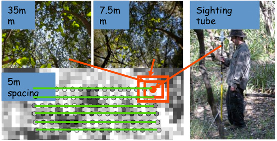
Transects for measuring canopy cover in riparian zones
Georeferenced photo transect surveys are commonly used in the marine environment, although the environments are totally different the principle of the approach could be applied in terrestrial environment as well. An overview of the approach used in the marine environment is given here.
Reference:
Johansen, K., Phinn, S., Lowry, J., and Douglas, D., 2008. Quantifying indicators of riparian condition in Australian tropical savannas: integrating high spatial resolution imagery and field survey data. International Journal of Remote Sensing. Vol. 29, No. 3, pp. 7003-7028.