Interpreting mapping accuracy
Comparing accuracy measures from different applications
The figure below shows four different mapping applications for which accuracies and number categories are calculated. The mapping applications represent common comparisons found in the literature conducted between different types of maps. These applications are: Map series for four mapping applications: (1) Resource mapping for sites: (a) Navakavu and (b) Eastern Banks 2007 ; (2) Change detection: (c) Eastern Banks seagrass cover mapped in 2004 and (d) 2007; (3) Differences in image type: (e) Quickbird and (f) Landsat 5 TM and (4) Difference in mapping methods: (g) Supervised and (h) manual delineation (h).
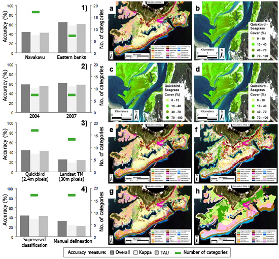
Comparing the accuracy measures of coral reef benthic maps to determine which map had the best quality for a specific application, requires simultaneous assessment of the number of mapping categories to support management decisions sufficiently. These accuracy measures, Overall, Kappa and Tau, follow the same trend and have a similar value. As a result, each measure led to the same conclusion when comparing accuracy values for a map for a specific mapping application.
Reference:
Roelfsema, C.M., and S.R. Phinn (2009b). Accuracy Assessment of Coral Reef and Seagrass Habitat Maps. International Journal of Remote Sensing, in press.