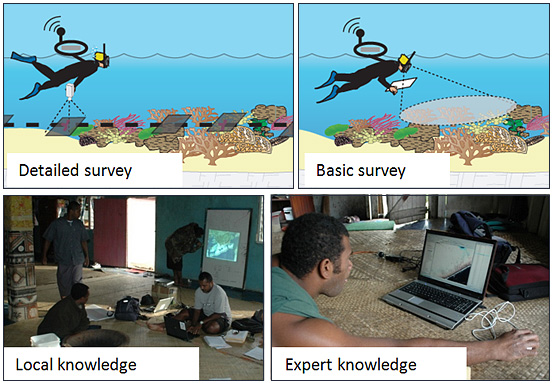
Benthic field data sources
Detailed field data: georeferenced photo transect surveys or video transects
Basic field data: spot check surveys
Local community knowledge: local community members interpret a satellite image. The image is projected on white paper, so areas with known benthic cover can be manually delineated and labelled by the community members. For example, the community members can be represented by local fishermen who are knowledgeable on the benthic composition, since they visit the study area on a regular basis.
Local expert knowledge: Local experts that are assumed to be knowledgeable about the study areas due to their regular visits over several years. Based on that, the experts assigned mapping categories to randomly distributed sample points, which were overlaid on the satellite image.
Reference:
Roelfsema, C.M. and S.R. Phinn (2008). Evaluating Eight Field and Remote Sensing Approaches for Mapping the Benthos of Three Different Coral Reef Environments in Fiji. In: Proceedings of SPIE Asia Pacific Remote Sensing Conference - Remote Sensing of Inlands, Coastal and Oceanic Water, Noumea, New Caledonia, 17-21 November 2008, Volume 7150.