What is remote sensing?
Remote sensing is any form of measurement where the measurement device is not in direct contact with the target. For example, the temperature of a water body can be measured directly by placing a thermal data logger in the water or indirectly using a satellite sensor that measures the temperature of the earth's surface.
In coastal environments remote sensing techniques are usually applied to map: water depth; the concentration of materials in the water column (e.g. chlorophyll and suspended sediments); and the type of material present on the substrate (e.g. seagrass) and is structural and/or physiological properties (e.g. seagrass density or biomass). A range of remote sensing data types can be used in coastal environments, including passive instruments which rely on reflected sunlight and active systems, such as sonar, which generate their own source of illumination.
Understanding remote sensing images
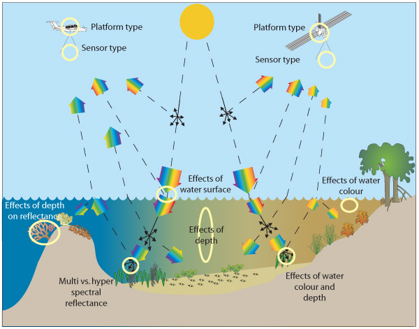
Images recorded by passive systems (Figure 1) contain a record of how sunlight in specific wavelength regions of colours is absorbed and scattered by the water column and benthic substrate. Understanding and processing images of the coastal environment requires an understanding of all the interactions.
This toolkit focuses mainly on passive systems and describes their use for a range of coastal mapping applications in a range of environments, in terms of depth and water clarity gradients.
Attributes of remote sensing data
The following terms are used to differentiate between the range of commercially available image data sets. Each term or resolution attribute determines how much and what type of information can be extracted from an image of the coastal environment.
Spatial dimensions
- This refers to the width, length and area covered by a satellite or airborne image (e.g. 10 km x 10 km) and the pixel size, e.g. 2.4 m and 30 m in the Quickbird and Landsat Thematic Mapper images below.
- These dimensions, along with size of features in an environment, control the level of detail and size of features able to be mapped.
- See example.
Type of sensor
- Images can either be from passive or optical sensors. Passive systems measure reflected sunlight and cannot operate through smoke or cloud or at night. These systems cannot provide substrate information in optically deep water, due to depth or clarity. Active systems illuminate the target with their own source of energy and measure the response, this includes acoustic, imaging radar and airborne laser systems.
Type of spectral bands (light)
- An additional control on the type of information measured is the number and placement of spectral bands, which are the regions in which reflected or emitted light are measured. Multispectral systems measure fewer than 10 bands and hyperspectral systems cover > 10 bands.
Frequency of image acquisition
- Images are acquired by sensors on satellites which are typically in polar orbit with a regular revisit time, that is they collect an image over a set location at the same time at a regular repeat cycle. For some sensors, often with pixels > 250m, this is a daily repeat. For other sensors it may vary from 4-16 days and may be less if the sensor has pointable optics.
Transforming remote sensing data to information
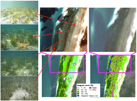
- Once an image for a coastal environment has been acquired it is then subject to a sequence of image processing operations to allow it to be integrated with other spatial data and to represent a thematic (Figure 2) or continuous map of the variable of interest. A number of approaches are available to conduct this type of processing and to deliver useful maps.
Coastal environment features that restrict the use of remote sensing substrate and water quality mapping
Mapping of coastal features from image data sets is complicated by the following factors:
- water clarity: increased water clarity increase the ability to map substrate features but decrease the ability to map water quality features
- water depth: increases water depth decreased the ability to map substrate features but increase the ability to map water quality features
- water roughness: increases water roughness reduces the ability to map substrate features
- cloud cover: unable to correct for
- cloud shade: reduce the quality but can correct for
- smoke: difficult to correct for depending on the thickness