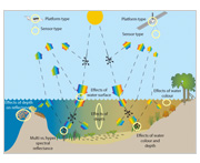
Aim of the marine remote sensing toolkit
To show managers, scientists and technicians working in marine environments how images collected from satellites and aircraft (remote sensing) can be used to map and monitor environmental features or processes and their change over time.
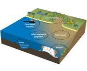
Marine environments
We recognise that marine environments encompass a broad range of environments, however, this toolkit focuses on coastal/inshore and oceanic/offshore water bodies, seagrass and coral reefs, and mangroves.
Start using the toolkit
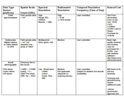
Select a preferred interface for obtaining:
- suitable remote sensing data and techniques from the marine toolkit, or
- resources providing background information on the marine remote sensing process.