Pre-processing sequence
Before any information is derived from a satellite image set, a series of steps needs to be conducted:
- Image acquisition
- Planning image correction
- Radiomentric corrections
- Geometric corrections
- Masking unwanted areas
Pre-processing sequence:
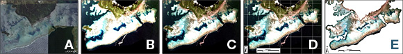
The figure above represents the key pre-processing steps, A) exploratory work to determine what imagery is suitable for the questions being asked, B) acquisition of the raw image for processing, C) application of radiometric corrections, D) geometric corrections, and E) masking out land and deep water areas.
The figure above represents the key pre-processing steps, A) exploratory work to determine what imagery is suitable for the questions being asked, B) acquisition of the raw image for processing, C) application of radiometric corrections, D) geometric corrections, and E) masking out land and deep water areas.
Reference:
Phinn, S.R, Roelfsema, C.M. and Stumpf, R. (2009). Remote sensing: the promise and the reality. In: Dennison, W., (Ed.) Coastal Assessment Handbook, Chapter 15, University of Maryland.