Bathymetry
Bathymetry is often acquired:
- to calibrate and validate bathymetry that is derived form optical remote sensing imagery using existing algorithms (e.g. Lyzenga et al.)
Bathymetry can be acquired by:
- Extracting data from existing nautical maps
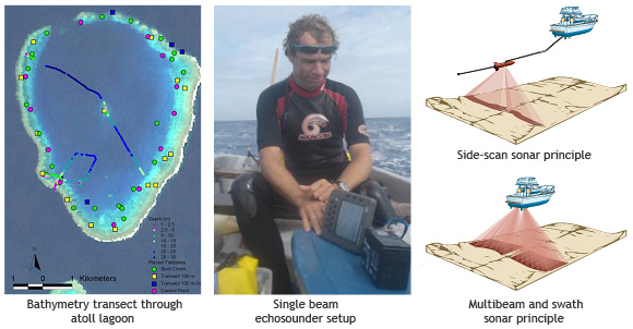
- Basic handheld GPS linked to echo sounder
- Side scan sonar survey
- Airborne laser depth sounding sensors (LiDAR, e.g. the SHOALS system)
References
Lyzenga, D. R., C. T. Wezernak and F. C. Polcyn (1976). Spectral band positioning for purposes of bathymetry and mapping bottom features from satellite altitudes. Ann Arbor, Michigan, ERIM
Lyzenga, D. R. (1985). "Shallow water bathymetry using combined lidar and passive multispectral scanner data." Int. J. Remote Sensing 6(1): 115-125
Penrose, J. D., P. J. W. Siwabessy, A. Gavrilov, L. Parnum, L. J. Hamilton, A. Bickers, B. Brooke, D. A. Ryan and K. Kennedy (2005). Acoustic Techniques for Seabed Classification. Technical Report 32. Brisbane, Coastal, Eastuarine and Waterways CRC. 32: 130