Change in sea surface temperature
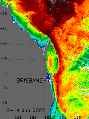
The above animation shows MODIS weekly-mean SST images for 8 June to 9 August 2007 for the region 22°S-30°S; 150°E-156°E showing a cyclonic eddy developing on the continental shelf south of Fraser Island at ~26°S before propagating southward along the east Australian continental slope. The solid black line represents the 200m isobath.
MODIS data are provided by the NASA Ocean Biology Processing Group (oceancolor.gsfc.nasa.gov).For further detail, please contact the project team (sees.rsrc_rstoolkit@uq.edu.au).
Reference:
Weeks, S. J., R. Barlow, C. Roy and F. A. Shillington (2006). "Remotely sensed variability of temperature and chlorophyll in the southern Benguela: upwelling frequency and phytoplankton response." African Journal of Marine Science 28(3-4): 493-509.