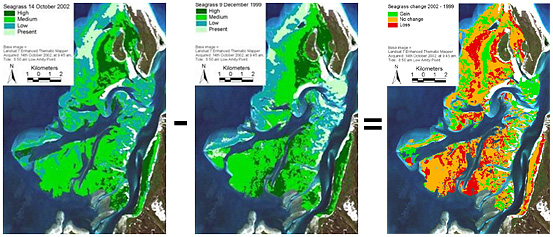
Changes in seagrass abundance
Roelfsema, C. M., M. Lyons, E. M. Kovacs, P. Maxwell, M. I. Saunders, J. Samper-Villarreal, and S.R. Phinn. (2014). "Multi-Temporal Mapping of Seagrass Cover, Species and Biomass: A Semi-Automated Object Based Image Analysis Approach." Remote Sensing of Environment 150(0), pp: 172-187. doi: 10.1016/j.rse.2014.05.001
Roelfsema, C.M., E. Kovacs, S.R. Phinn, M. Lyons, M. Saunders and P. Maxwell (2013) Challenges of Remote Sensing for Quantifying Changes in Large Complex Seagrass Environments. Estuarine, Coastal and Shelf Science doi:10.1016/j.ecss.2013.01.015.
Lyons MB, Roelfsema CM, Phinn SR (2013) Towards Understanding Temporal and Spatial Dynamics of Seagrass Landscapes using Time-series Remote Sensing. Estuarine, Coastal and Shelf Science. doi:10.1016/j.ecss.2013.01.015.