Temporal vs spatial resolution
Rule of thumb:
- Extremely high - multiple daily
- airborne sensor, high spatial resolution and small extent (e.g. CASI)
- High - daily
- satellite sensor, low spatial resolution and large extent (e.g. MODIS)
- Medium – weekly
- satellite sensor, high spatial resolution and moderate extent (e.g. Worldview 2)
- Low – < monthly, seasonally or yearly
- satellite sensor, moderate spatial resolution and large spatial extent
(e.g. Landsat Enhanced Thematic Mapper 7)
- satellite sensor, moderate spatial resolution and large spatial extent
Spatial and temporal resolution for selected parameters
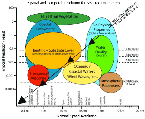
Spatial and temporal scales of coastal monitoring applications in relation to the pixel size of commercially available airborne and satellite image data sets. In Phinn et al., 2010 and modified from Jensen, 2007.
Reference:
Phinn, S.R, Roelfsema, C.M. and Stumpf, R. (2010). Remote sensing: the promise and the reality. In: Dennison, W., (Ed.) Coastal Assessment Handbook, Chapter 15, University of Maryland.