Mapping and monitoring options: Predicting coral bleaching
The primary cause of spatially extensive or mass coral bleaching events is unusually high sea temperature (Hoegh-Guldberg, 1999). Remote sensing technologies can be used to detect the excessive and persistent sea temperature anomalies that are likely to result in a coral bleaching event. A summary of remote sensing platforms available for monitoring sea surface temperature is available here.
A number of indices have been developed to refine the relationship between temperature and bleaching (e.g. NOAA Hotspots and Degree heating weeks, ReefTemp).
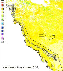
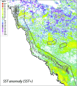
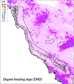
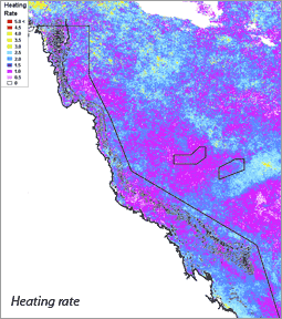
The four different ReefTemp temperature indices are shown below:
References
Hoegh-Guldberg, O. (1999). Climate change, coral bleaching and the future of the world's coral reefs. Marine and Freshwater Research 50:839–866.
Maynard, J.A., Turner, P.J., Anthony, K.R.N, Baird, A.H., Berkelmans, R., Eakin, C.M., Johnson, J., Marshall, P.A., Packer, G.R., Rea, A., and Willis, B.L. (2008). ReefTemp: An interactive monitoring system for coral bleaching using high-resolution SST and improved stress predictors. Geophysical Research Letters, Vol. 35, L05603.
NOAA Coral Reef Watch (2011) Methodology, Product Description, and Data Availability of NOAA Coral Reef Watch (CRW) Operational and Experimental Satellite Coral Bleaching Monitoring Products. http://coralreefwatch.noaa.gov/satellite/methodology/methodology.php#reference