Fundamentals of image processing
and mapping approaches
This section will explain the main image processing steps to map biophysical properties using remote sensing imagery derived from passive sensors. The steps described will focus on:
The figure above represents the processing steps to get from image to final map. Roll your mouse cursor over the numbers to view the steps (source Assessment Handbook).
Pre-processing sequence:
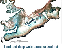
Image acquisition, Types of corrections, When to correct, Radiometric corrections, Geometric correction & Masking (e.g. water, cloud)
Field data for calibration and validation:
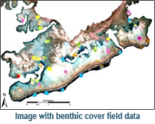
Spectral library collection & Optical properties
Commonly used mapping approaches:
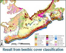
Manual delineation and labelling, Object based analysis, Supervised classification, Unsupervised classification, Inverse modelling, & Regression analysis
Detecting change and trends:
What is change and trend detection?, Image requirements, Trend detection and analysis, Example time series imagery
Delivering a remote sensing product:
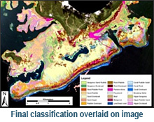
Post classification refinement, Error assessment procedures, Evaluate error matrix using appropriate statistics & Communication of map products
Reference:
Jensen, J. R. (2005). Introductory digital image processing: a remote sensing perspective. Third edition, Prentice Hall: 316.
Phinn, S.R, Roelfsema, C.M. and Stumpf, R. (2009). Remote sensing: the promise and the reality. In: Dennison, W., (Ed.) Coastal Assessment Handbook, Chapter 15, University of Maryland.