Resolusi temporal vs spasial
Aturan praktis:
- Sangat tinggi - beberapa kali sehari
- sensor wahana udara, resolusi tinggi dan liputan sempit (mis. CASI)
- Tinggi - harian
- sensor satelit, resolusi spasial rendah dan liputan luas (mis. MODIS)
- Sedang – mingguan
- sensor satelit, resolusi spasial tinggi dan liputan sedang (mis. Worldview 2)
- Rendah – < bulanan,
musiman atau tahunan
- sensor satelite, resolusi spasial sedang dan liputan luas
(mis. Landsat Enhanced Thematic Mapper 7)
- sensor satelite, resolusi spasial sedang dan liputan luas
Resolusi spasial dan temporal untuk parameter terpilih
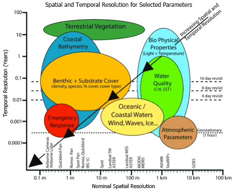
Spatial
and temporal scales of coastal monitoring applications in relation to
the pixel size of commercially available airborne and satellite image
data sets. In Phinn et al., 2010 and modified from Jensen, 2007.
Referensi:
Phinn, S.R, Roelfsema, C.M. and Stumpf, R. (2010). Remote sensing: the promise and the reality. In: Dennison, W., (Ed.) Coastal Assessment Handbook, Chapter 15, University of Maryland.