Dimensi spasial dimensions
Resolusi spasial: Halus, sedang dan kasar
Skala spasial data penginderaan jauh dikategorikan menjadi:
- Halus/tinggi < 5m
- Sedang 5 m - 100 m
- Kasar/rendah >100 m
Resolusi spasial halus: 2.4m piksel
Resolusi spasial kasar: 25m piksel
Hubungan antara resolusi spasial dan liputan spasial
Dimensi spasial dari citra dan sensor pencitraan menyatakan (1) ukuran piksel; dan (2) luas area yang dicakup oleh gambar. Hal ini saling terkait seperti yang ditunjukkan pada diagram berikut:
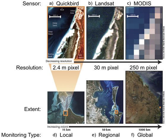
These
true-color images show the variation in spatial sampling unit (pixel)
and aerial coverage (extent)
between three commonly-used satellite imaging sensors: Quickbird,
Landsat Thematic Mapper, and Terra-MODIS.
Figure a-c show the effects of differences between pixel sizes, and
resultant spatial resolutions for the same area of
water-seagrass-mangrove-urban area in Moreton Bay, Australia. Figures
d-f show the section of one image captured
by each of the three image sensors. The maximum extent of ground width
able to be imaged by each sensor is 16 km
(Quickbird), 185 km (Landsat TM), and 2000 km (MODIS)
Referensi:
Phinn, S.R, Roelfsema, C.M. and Stumpf, R. (2009). Remote sensing: the promise and the reality. In: Dennison, W., (Ed.) Coastal Assessment Handbook, Chapter 15, University of Maryland.