ArcGIS
Tools: Land Use Impact Model (LUIM)
The
Land Use Impact Model (LUIM) is a risk assessment framework for land
degradation that has been developed as an extension to a GIS (
ESRI).
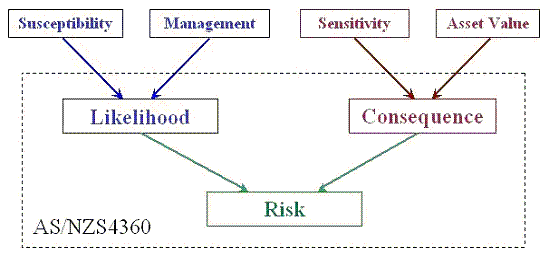
The conceptual design of the LUIM risk assessment framework is shown in
Figure 1 below. The framework is based on the Australian and New Zealand
Risk Management Standard (AS/NZS4360) defined by
Standards Australia (Risk
Management AS/NZS4360:1999)
The LUIM framework
operates on land units (also called unique mapping areas) and assesses
the risk posed by land degradation processes (such as soil erosion, soil
structure decline, soil acidification, etc.) for land units.
Risk
is determined through an assessment of
Likelihood
and
Consequence:
-
Likelihood
is the chance of a certain level of land degradation occurring on a
particular land unit. This depends on the
Susceptibility
of a land unit to the land degradation process under investigation
(such as soil erosion) and the role that
Management
practice may play in causing, aggravating or moderating that
process.
-
Consequence
is the anticipated impact that land degradation will have on a land
unit should it occur. This depends on the ability of the land unit
to maintain its function or productive potential if degradation
occurs (Sensitivity)
and on the value of the land unit in economic, environmental and
social terms (Asset
Value).
The risk posed by a land degradation process
increases for a land unit as the likelihood of land degradation
occurring increases and the consequence, should it occur, increases.
-
Download LUIM Help File (3,928KB)
- Joanne McNeill, J., MacEwan, R., Crawford, D. (2007)
Using GIS and a Land Use Impact Model to Assess Risk of Soil Erosion in
West Gippsland, Applied GIS 2(2): pp. 19.1–19.16. DOI: 10.2104/ag060019
- Report on the
Land Use Impact Model Feb. 2007, Department of Primary Industries,
Primary Industries Research, Victoria, Australia.
The Land Use Impact Model (LUIM) ArcGIS Extension:
<%
agreed=request.form("agree_to_terms")
email1=request.form("email_address")
ArcGISVer=request.form("ArcGISVer")
dl_name=request.form("dl_name")
dl_company=request.form("dl_company")
if agreed="" or agreed="No" then
%>
<%
end if
if agreed="Yes" and email1>"" then
' send email to David, ifthat worked then show downloads:
set iMsg = Server.CreateObject("CDO.Message")
set iConf = Server.CreateObject("CDO.Configuration")
' Set Flds = iConf.Fields
With iConf.Fields
.Item("http://schemas.microsoft.com/cdo/configuration/sendusing") = 2
.Item("http://schemas.microsoft.com/cdo/configuration/smtpserver") = "smtp.uq.edu.au"
.Item("http://schemas.microsoft.com/cdo/configuration/smtpconnectiontimeout") = 10
.Item("http://schemas.microsoft.com/cdo/configuration/smtpserverport") = 25
.Update
End With
on error resume next
With iMsg
Set .Configuration = iConf
.To = "d.pullar@uq.edu.au"
.From = email1
.Subject = "LUIM download"
.HTMLBody = dl_name & " downloaded LUIM for ArcGIS " & ArcGISVer & "
e-mail: " & email1 & "
Company: " & dl_company
.Send
End With
if err<>0 then
response.write "Sorry, could not send the message, please check the email address!
- Go Back -"
err=0
else
response.write "
Thank you, " & email1 & " - Please download :
"
if ArcGISVer="91" then
response.write "LUIM for ArcGIS 9.1"
elseif ArcGISVer="92" then
response.write "
LUIM for ArcGIS 9.2"
else
response.write "Sorry, something went wrong "
end if
end if
' ----------------------------------------------------------------------
end if
%>
Contact David Pullar